
No account needed

Five 3D drill models, open to everyone

Every model on Prospector Trails is built from a listed company's own published drill results and placed on real terrain and imagery. These five are open to everyone, so you can try exactly what a free account gives you on every model on the globe.

New to drill results? The investor flight simulator walks you through one real Luni release, from its headline down to the intervals in 3D, then hands you the full model.

Showing them on a stand or in a lobby? Planet of mines plays all five, with the stories, as a full-screen tour.

globe.prospectortrails.com/chalice-gonneville-julimar
The Gonneville PGE-Ni-Cu-Co deposit 3D model: 994 drill holes on terrain and satellite imagery, with the top intervals listed and a grade slider

Chalice Mining · ASX: CHN

Gonneville PGE-Ni-Cu-Co deposit

Julimar, Western Australia · Palladium, platinum, nickel, copper, cobalt

Chalice found Gonneville in 2020, about 70 km north-east of Perth, and has since drilled it out into a large palladium-nickel-copper-cobalt deposit. A Pre-Feasibility Study with a maiden Ore Reserve followed in December 2025.

994holes placed
302,834 mdrilled
4,342intervals
28releases

Top interval by grade × metres: JD002: 75.1 m at 6.22 g/t palladium

Why it works in 3D

  • The size, in one glance. Nearly a thousand holes and over 4,000 intervals is a table no investor will read. In 3D the whole intrusion appears as one body under the farmland, from surface to more than a kilometre down.
  • Grade inside the bulk. The grade slider lights up the high-grade palladium zones inside the broad mineralised envelope, which is the question every analyst asks about a large low-grade deposit.
  • Platinum and copper too. Switch the colouring between palladium, platinum and copper to see how the metals line up, without opening a single PDF.
Cite this model

Prospector Trails (2026). Gonneville PGE-Ni-Cu-Co deposit, in 3D. Schematic model from Chalice Mining's published releases. https://globe.prospectortrails.com/chalice-gonneville-julimar

globe.prospectortrails.com/patriot-battery-metals-shaakichiuwaanaan
The Shaakichiuwaanaan lithium project 3D model: 1,126 drill holes on terrain and satellite imagery, with the top intervals listed and a grade slider

Patriot Battery Metals · ASX: PMT · TSX: PMET

Shaakichiuwaanaan lithium project

James Bay, Quebec, Canada · Lithium, tantalum, caesium

Shaakichiuwaanaan (formerly Corvette) holds the CV5 and CV13 spodumene pegmatites in the James Bay wilderness. The October 2025 Feasibility Study put a maiden Probable Reserve on CV5 of 84.3 Mt at 1.26% Li₂O.

1,126holes placed
291,210 mdrilled
1,757intervals
36releases

Top interval by grade × metres: CV22-083: 157.0 m at 2.12% Li₂O

Why it works in 3D

  • Somewhere almost nobody will visit. The project lies deep in the James Bay lake country. The model puts CV5, CV13 and the outlying pegmatites on real terrain and imagery, so an investor in London or Sydney can see the trend for themselves.
  • Continuity you can see. Hundreds of thick lithium intervals stack along the CV5 trend. The best ones run past 150 m, and in 3D it is obvious how they connect.
  • Three metals, one model. Switch between lithium, tantalum and caesium. The release picker replays how the drilling stepped out over 36 announcements.
Cite this model

Prospector Trails (2026). Shaakichiuwaanaan lithium project, in 3D. Schematic model from Patriot Battery Metals's published releases. https://globe.prospectortrails.com/patriot-battery-metals-shaakichiuwaanaan

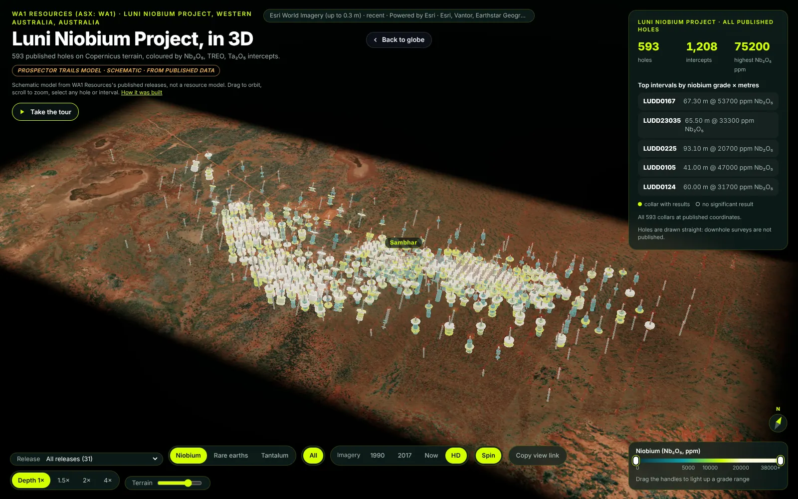
globe.prospectortrails.com/wa1-luni
The Luni niobium project 3D model: 593 drill holes on terrain and satellite imagery, with the top intervals listed and a grade slider

WA1 Resources · ASX: WA1

Luni niobium project

West Arunta, Western Australia · Niobium, rare earths, tantalum

WA1 found niobium at Luni in 2022, under the remote West Arunta desert. It has grown to a 220 Mt Mineral Resource at 1.0% Nb₂O₅ (May 2026), with a Pre-Feasibility Study due by the end of 2026.

593holes placed
67,473 mdrilled
1,208intervals
31releases

Top interval by grade × metres: LUDD0167: 67.3 m at 5.37% Nb₂O₅

Why it works in 3D

  • Up to date the morning after. WA1's latest drilling, released on 19 October 2026, is already on the model (and is the release the investor flight simulator walks through). The release picker shows each programme on its own, so the newest holes are easy to find.
  • A remote deposit made visible. The model sets the carbonatite's drilling against the red desert and its salt lakes, far from any town.
  • Niobium and rare earths together. The same intervals carry niobium, rare earths and tantalum. One switch changes which metal you are looking at.
Cite this model

Prospector Trails (2026). Luni niobium project, in 3D. Schematic model from WA1 Resources's published releases. https://globe.prospectortrails.com/wa1-luni

globe.prospectortrails.com/deep-yellow-tumas
The Tumas uranium project 3D model: 5,610 drill holes on terrain and satellite imagery, with the top intervals listed and a grade slider

Deep Yellow · ASX: DYL

Tumas uranium project

Erongo, Namibia · Uranium

Tumas sits in Namibia's Erongo uranium province, home to the Rössing and Husab mines. It is a shallow palaeochannel deposit, with an Ore Reserve of 79.3 Mlb U₃O₈ (December 2024).

5,610holes placed
105,606 mdrilled
3,310intervals
30releases

Top interval by grade × metres: T3I284: 7 m at 5,820 ppm eU₃O₈

Why it works in 3D

  • A thin orebody made readable. Tumas is wide, shallow and flat. Depth exaggeration of 5×, 10× or 20× turns a layer a few metres thick into something you can actually see along the old river channels.
  • Every hole since 2015. 5,610 published RC holes from 30 releases. At this density only a model can show where the drilling is, and what each programme added.
  • Thirty-five years of imagery. Imagery from 1991, 2001, 2017 and today shows how the ground has changed around the project.
Cite this model

Prospector Trails (2026). Tumas uranium project, in 3D. Schematic model from Deep Yellow's published releases. https://globe.prospectortrails.com/deep-yellow-tumas

globe.prospectortrails.com/hot-chili-costa-fuego
The Costa Fuego copper-gold project 3D model: 285 drill holes on terrain and satellite imagery, with the top intervals listed and a grade slider

Hot Chili · ASX: HCH · TSXV: HCH

Costa Fuego copper-gold project

Atacama Region, Chile · Copper, gold, molybdenum, silver

Costa Fuego groups the Cortadera, San Antonio, Productora and Valentina deposits into one copper-gold hub in Chile's coastal range. The March 2025 Pre-Feasibility Study set a maiden Probable Ore Reserve of 502 Mt.

285holes placed
79,647 mdrilled
283intervals
45releases

Top interval by grade × metres: CRP0020D: 972 m at 0.50% Cu

Why it works in 3D

  • A hub, shown as a hub. The model puts all four deposits on one piece of terrain, so the hub-and-spoke plan makes sense at a glance: how far apart they are, and where the drilling is.
  • Long porphyry intervals. Porphyry copper means intervals close to a kilometre long. In 3D you see how deep they reach, not just a grade in a table.
  • Honest about accuracy. 184 collars sit at published coordinates. The other 101 are placed from release maps, and each carries a ring showing its ±50 m error.
Cite this model

Prospector Trails (2026). Costa Fuego copper-gold project, in 3D. Schematic model from Hot Chili's published releases. https://globe.prospectortrails.com/hot-chili-costa-fuego

For listed companies

Your project may already be on the globe. Claim it.

We build a schematic model for every project with published drill results. Claiming it is how it becomes your official model, on your website and in front of your investors.

Company verified

Your team checks the model and we add the "Company verified" badge, with your Competent Person named as reviewer.

Survey-grade, not schematic

Send collar surveys, downhole surveys and assay tables, and the "schematic" label comes off. Holes follow their real traces.

On your own website

One line of embed code, in your colours and with your logo, for your site, investor deck and results-day announcement.

Updated on results day

We follow your releases on the ASX, RNS and newswire feeds and add new holes the morning they are published.

See who is looking

View counts and time spent on your model, as totals, so you can tell which results caught investors' attention.

One link for investors

A link that opens on any phone with nothing to install, ready for emails, posts and roadshows.

These models are schematic, built by Prospector Trails from each company's public releases, and are not endorsed by the companies shown. They are for viewing only, are not resource models, and are not investment advice. Figures on this page are as shown on the models on 24 October 2026. Imagery: Esri World Imagery and Copernicus Sentinel data; terrain: Copernicus DEM GLO-30.